Traditional Lighthouses of Greece
In 1940 the network of Traditional Lighthouses of Greece were 206, but during the Second World War, (and particularly during the withdrawal of German troops away from Greece), they partially or totally destroyed most of them since they were strategic objectives. Others were destroyed by earthquakes e.g. the earthquakes of 1951 and 1957 Vardianoi and Fiscardo in the Ionian Islands which caused damage to lighthouses. Today there are 120 traditional lighthouses of which only 20 are in good condition. The first reconstruction of the network began in 1945 and continued until the mid 50's. Unfortunately until today all the lighthouses that survived wars and natural disasters are at risk. The lighthouses are buildings built to serve specific needs of navigation, primarily in their design had functionality and weather resistance. Today there are repaired and operated 82 Monitored lighthouses and many of them function as museums, especially those who are in or near cities or villages.
Lighthouses of Greece "Fiscardo Kefalonia Island"
Location: Fiscardo Kefalonia Island
Latitude: 38° 27' 39.9" N, Longitude 20° 34' 55.1" E
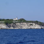
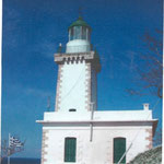
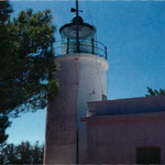
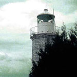
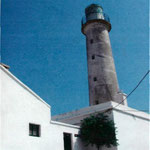
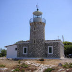
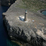
The stone lighthouse was built-in 1892 and located in the north of the island of Kefalonia. After the earthquake of 1953 the old lighthouse was abandoned and they built a new with square tower of
14.2 m and a height of 28 m. So today is unique in Greece, where exist in the same place two constructions lighthouses.
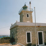
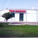
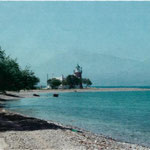
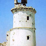
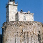
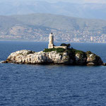
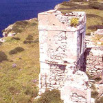
An old Venetian lighthouse from the 16th century, which resembles the shape of an ancient column, is located in the entrance of the port Fiscardo. In the area of the lighthouse is fenced with
stone masonry approximately 2-3 meters and there is a house for the guards of that era, which is now abandoned, unattended and in poor condition. The importance of this lighthouse (the time of
the Venetian occupation), was very high because of its port of Fiscardo. The inner harbor is very narrow for large vessels, but the depth is sufficient. The small fleet of the Venetians found
good anchorage SW of Lighthouse. Fiscardo was the main export port from the whole region, from where there loaded all products (wine, oil, etc.). Today the traditional village Fiscardo is the
most famous touristic place in Ionian Islands and not only. There are a lot of famous very rich or extremely rich people who visit it with large or super extra large Yachts from all over the
planet. By the way is my home village, if you want, visit my other blog which is written in the Greek language: http://myfiscardo.wordpress.com/
The stone lighthouse was built in 1892 and located in the north of the island of Kefalonia. After the earthquake of 1953 the old lighthouse was abandoned and they built a new with square tower of
14.2 m and a height of 28 m. So today is unique in Greece, where exist in the same place two constructions lighthouses.
Location: Agioi Theodoroi Kefalonia Island
Latitude: 38° 11' 29" N, Longitude: 20° 28' 4.6" E
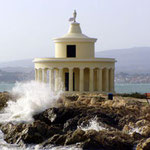
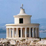
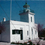
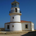
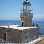
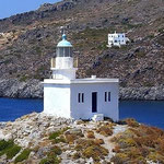
Located on the east side of the Gulf of Argostoli close to an area called Katavothres, at the northwestern of a cape, protecting the harbor of Argostoli the capital of the Kefalonia island or you
will see it if you take the boat to Lixouri village. It is a circular structure with 20 columns and its tower is 8 m tall. The building has a rather simple and Doric architectural style, while
its focal plane is 11 m.
It was originally built-in 1828 by the British administrator Charles Napier, who ruled the island that time. In 1863, after the integration of the island to the Greek State, this lighthouse was
included in the lighthouse network of Greece.
The earthquake of 1953, that hit severely Kefalonia and the other Ionian islands, destroyed the lighthouse. It was rebuilt in 1960 by a local architect Takis Pavlatos. The lighthouse gives a
romantic view at night and gives you a great place to walk, relax, swim and take photos of the great view.
Location: Gerogompos (Kefalonia Island)
Latitude: 38° 10' 48.5" N, Longitude: 20° 20' 29.9" E
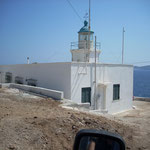
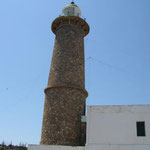
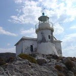
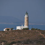
It was manufactured in 1907 from the British. The lighthouse is located in the end of homonym cape in the Kefalonia Island about 12 km west of Lixouri. The altitude of tower is 13 meters and the
height of focal plane is 58 meters.The original lighthouse was destroyed by the retreating German troops at the end of Word War II and rebuild in 1947 using the same plans as the original.
Location: Vardiani Island (Kefalonia)
Latitude: 38° 8' 0.1" N, Longitude: 20° 25' 35.7" E
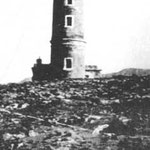
Vardiani island is at the entrance of the Gulf of Argostoli (Kefalonia) and builded by British Charles James Napier in 1824. There was a 34m. high lighthouse but destroyed after the 1953's
earthquakes and now you can see only some of the ruins.
Lighthouses of Greece "Sideros Corfu Island"
Location: Sideros Corfu Island
Latitude: 39° 37' 22.9" N, Longitude: 19° 55' 46.1" E
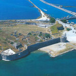
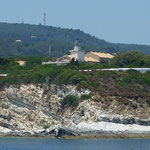
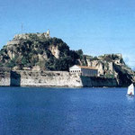
The conical stone lighthouse at Cape Sidero sits on the Venetian fortress overlooking Corfu Harbor. The Venetians cut a moat between Cape Sidero and the town, when they built the fortress. The
fort is an important archaeological and historical site today.
Sidero with a height of tower 8.5 m and focal plane 78 m, was built by the British in 1822. It had a simple fixed light but a few years later the lighthouse was equipped with new lens made by
Sautter & Lemonier of France. In 1863 the lighthouse was ceded to the Greek government when the British left the Ionian Islands. The lighthouse along with much of the town of Corfu has
suffered in wartime. In October 1915 the British merchant ship Sailor Prince was captured by a German U-boat near the lighthouse. During World War II (1943) the tower was damaged by the German
army.
Lighthouses of Greece "Peristeres Kaparelli"
Location: Peristeres
Latitude: 39° 47' 33" N, Longitude 19° 57' 33.1" E
The lighthouse it's a stone cylinder tower and was constructed by the British at 1828 during their rule of the Ionian Islands. A light was exhibited from a rocky islet off the north-east of Corfu
Island at Peristeres (means the "doves" or "pigeons"). It was one of the first beacons established in Greece after the War of Independence. The first light may have been a simple column holding a
beacon. It signaled the entrance to the narrow passage between Corfu and the mainland. In 1872 the beacon needed to be replaced and a sturdy stone tower was built. Unfortunately the lighthouse is
now in ruins due to earthquakes and attacks by German bombers during World War II but still keeps a small modern beacon on the site. The lighthouse is sometimes called "Kaparelli Light" or
"Tiniozo Light". It is a guide for ships headed south out of the Adriatic Sea and the Albanian coastline. It is accessible only by private boat and very dangerous to visit.
Lighthouses of Greece "Kastri Othonoi Island"
Location: Othonoi Island
Latitude 39° 51' 53.6" N, Longitude 19° 25' 45.2" E
Othoni Island, lies about 11 miles northwest of Corfu Island and is the western most island in Greece and the northern most of the Ionian Islands. It is one of the "Diapontia" Islands, satellites
of the larger Corfu. The altitude of tower is 13 meters and the height of focal plane is 106 m. The conical white tower rises from a square dwelling. It was damaged during World War II by bombs
& was unlit the periods 1941-1954. The kerosene beacon was then restored until 1985 when it was electrified. The lighthouse is not open to the public. Othonoi Island is accessible only by
boat and a small ferry goes to Othonoi from Corfu. From the small port village of Othonoi, a road leads to the northeastern point of the island where the lighthouse is located.
The seas separating it from its mother island, it's usually quiet but, danger arises when the area receives strong westerly winds and cold air from Adriatic Sea. Perhaps it was a west wind that
blew Odysseus to the island. Homer wrote that Calypso held Odysseus captive in a cave on Othonoi Island.
Lighthouses of Greece: Lakka Paxoi Island
Location: Paxos Island
Latitude 39° 14′ 8.6″ N, Longitude 20° 7′ 41.4″ E
Lakka is situated on the northern part of Paxoi Island 8 miles south from Corfu Island. The original lighthouse was built by the British in 1825 but an earthquake at 1913 (directly under the
lighthouse) causing it to collapse. The entire lighthouse fell into the crevasse and was covered by dirt. It was rebuild in 1919, it’s 9 m height and the current beacon is visible for 20 miles
which can be seen well to the west. The square stone tower is attached to a single story dwelling. The large cave Ipapanti is a popular destination for tourists who travel to it by water taxi
passing the lighthouse. The lighthouse is not open to the public but the grounds are easy to access from Lakka. The distance from capital of the island (Gaios) is about 10 Km.
Lighthouses of Greece: Panagia Paxoi Island
Location: Panagia Paxoi Island
Latitude 39° 12.0' N, Longitude 20° 12.0' E
It's located on the tiny island Panagia (Virgin Mary)where above is the lighthouse and the monastery, in the entrance of the harbor Gaios of Paxos island. It was built by the British in 1825 and
was working with oil, then in 1890 with petrol and in 1982 with solar.
Lighthouses of Greece: Oboros Antipaxoi Island
Location: Oboros Antipaxoi Island
Latitude 39° 8' 26.4" N, Longitude 20° 14' 54.2" E
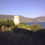
The lighthouse is located on Cape Ovoros on the south-east of Antipaxoi Island. It's a stone square tower 7.2 m, was build in 1906 with petrol. During the second World War was not working and in
1945 started again. A stone wall surrounds the compound. Inside the tower the keepers have an exhibit of old equipment and tools from early days. The island is accessible by private boat or water
taxi from Paxoi & its an easy walk from the landing to the lighthouse.
Lighthouses of Greece: Murtos (Sivota)
Location: Murtos (Sivota)
Latitude 39° 24' 12" N, Longitude 20° 12' 55" E
The lighthouse was manufactured in 1884 from the French Company of Ottoman lighthouses. In 1941 was destroyed by the Germans. It's a white octagon tower 14 m height and of focal plane is 87 m.
The access to the lighthouse becomes with boat from Sivota, known from the famous naval battle in 433 b.C. between the people of Corinth & Corfu. The two green islands at the bay of Murtos
are considered from the name of the pirate, according to the traditions, as Sivota islands.
Lighthouses of Greece: Lefkas
Location: Lefkas Island
Latitude 38° 50' 43.2" N, Longitude 20° 43' 11.5" E
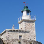
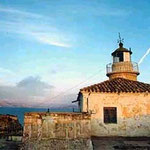
It's located in the northern part of the fortress of Santa Maura, inside the bastion of the Almighty, builded with 6 m height square tower and a lighthouse. The altitude of tower is 6,5 m and the
height of focal plane is 17 m.The Lighthouse operated for the first time in 1861 with oil. In 1889 with petrol until 1953 when the old machines were replaced with automatic acetylene torch and
from 1990 with solar power.
Access to the lighthouse is easy since it is located on the walls of the castle of Santa Maura at the edge of the canal bridge of Lefkas. The castle once embraced the city and cut off the road
into enemies and pirates. Built around 1300 by the Frankish ruler John Orsini who took "Lefkada" for dowry in marriage with the daughter of Epirus Nikephoros A. It is one of the most imposing
castles of its time. In 1479 the castle was occupied by the Turks. Then they built a large bridge with 360 arches that crossed the lagoon from the beach to the position "Kalkani". Unfortunately
it was destroyed by earthquakes but some tracks are saved into the lagoon. The stone lighthouse of the last century (1861) & the church of Agia Mavra inside the castle survived completely.
Lighthouses of Greece: Cape Dukato (Kavos Kiras)
Location: Lefkas Island
Latitude 38° 33' 48.8" N, Longitude 20° 32' 34.1" E
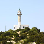
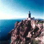
The Lighthouse of Dukato is located in Cape Dukato (or Kavos Kiras), south of the island of Lefkas. The lighthouse was built-in 1890, the height of the tower is 14 m and the focal height of 70 m.
It is one of the most preferred Scuba Diving site in Lefkas but the currents are pretty strong and only divers with a lot of experience should dive with an expert guide. The light station stands
at the top of a spectacular cliff with a fantastic view of the islands Ithaca and Kefallonia.
Lighthouses of Greece: Skinari Zakynthos
Location: Zakynthos
Latitude: 37° 56.0′ N, Longitude: 20° 42.0′ E
It’s located above Cape Skinari, 67 m height from the sea, in the northern side of Zakynthos Island, about 1.5 km north of Corinth. The lighthouse is a round rocky tower 9.5 m height manufactured
in 1897. The area around the light station is well-known for the ‘BLUE CAVES’ cut into the limestone cliffs by the sea and for several historic stone windmills.
Lighthouses of Greece: Krioneri Zakynthos
Location: Zakynthos
Latitude: 37° 48.0' N, Longitude: 20° 54.0' E
This lighthouse located in Cape Krioneri the southeastern side of the island and it’s the narrowest path between the island and the mainland. The lighthouse was lit in 1832 and is one of the
oldest lighthouses in the Ionian Islands built by the British. Later in 1866 a new lighthouse was built at its current location in Krioneri. In the first year the lighthouse served consecutively
with olive oil and acetylene and then the 30s with electricity until 1953, when it was destroyed by the earthquake. The concrete tower was built-in 1955 of 8.2 meters and white, which was
installed on the automatic torch and operates today as unattended and unmanned.
Lighthouses of Greece: Kapsali Kythira Island
Location: Kythira Island
Latitude: 36° 8.55' N, Longitude: 23° 0.0' E
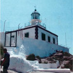
The lighthouse is in the top of hill Easterly from the harbor of graphic village Kapsali in the Kythira Island. It is easily accessible as it is located in the southern part of the island on the
right hill as you enter the beautiful harbor-bay Kapsali. Kapsali is the port of Hora of Kythira and the most cosmopolitan area of the island which gathers the attention of more visitors. The
village is built around two bays, where there are two beautiful beaches and a well equipped marina. The lighthouse has height 6 m and the focal height is 65 meters. It's established in 1853 by
the British and it was included in the Greek lighthouses network after 10 years.
Lighthouses of Greece: Mudari, Kythira Island
Location: Kythira Island
Latitude: 36° 23.0' N, Longitude: 22° 57.0' E
It was manufactured in 1901. The altitude of tower is 25 meters and the height of focal plane is 110 meters.
The lighthouse Mudari is located in Kythira island at Cape Spathi near to village Karava.
Lighthouses of Greece: Apolitares, Antikythira Island
Location: Antikythira Island
Latitude: 35° 50.0' N, Longitude: 23° 20.0' E
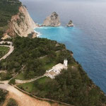
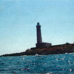
It's located near the Potamos village, on the Southern tip of Antikythira island 16 miles from the northwestern tip of Crete. The lighthouse keeps a lonely vigil over the seaway connecting the
Ionian Sea to the Aegean Sea and the Sea of Crete. The tower has a unique design. Its bottom portion is cylindrical while the top section is conical and stands at one end of a crumbling. The area
around the lighthouse, known as "Apolytares Point", is rugged and isolated, with sheer cliffs dropping to the sea on all sides of the station. The lighthouse was established in 1926 and has a
modern solar beacon with a range of 17 miles. It is not accessible by road and is not open to the public.
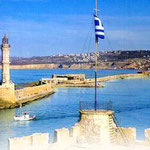
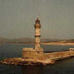
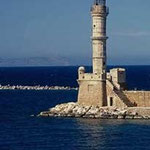
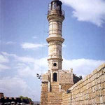
Lighthouses of Greece: Chania, Crete Island
Location: Crete Island
Latitude: 35º 31' 10'' N, Longitude: 24º 1' 0'' E
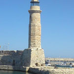
The Lighthouse has a height of 21 meters and the light covers a distance of 7 miles. It is the oldest not only of Greek and Mediterranean coasts, but also one of the oldest in the world. For more
than 5 centuries the lighthouse of Chania has been standing at the entrance of the city's old harbor. The lighthouse has been acknowledged as the trademark of the city all around the world. Its
history is connected with the history of the city's harbor. In 1212 A.D. the Venetians conquered Crete. Then they decided to build a new city on the remains of ancient "Kydonia" (today's Chania).
The harbor was constructed between the years 1320 and 1356 A.D. The works carried on for the next 200 years, it was during that period when the lighthouse was constructed in a different of
today's form. Documented information about his first lighting machine does not exist, as there is not any evidence to show when it stopped working as torch open flame. From 1645 until 1830, Crete
was under the Turkish occupation but they never used the harbor at Chania, instead they used the natural harbor at Souda. In 1830 England handed Crete over to Egypt and between 1847 - 1859 the
lighthouse was restored. In 1864 the lighthouse came under the French Company Ottoman Lighthouses. The lighthouse was reconstructed on its original base. The new lighthouse is now different from
the old one. It looks like a minaret with an internal stairway that leads to a balcony with a glass tower. The tower is divided by three diverse parts: the part of the base is an octagon, the
middle section is sixteen sides, and the third round. The material of the base is the same origin and quality that the Venetians built the fortifications of the city of Chania.
Lighthouses of Greece: Rethymno, Crete Island
Location: Crete Island
Latitude: 35º 22' 12.5'' N, Longitude: 24º 28' 39.5'' E
The lighthouse was manufactured in 1864 located in the harbor of Rethymno. Recent studies have shown that the origin is Egyptian and was built-in 1838 by Mehmet Ali, the period 1830-1840, when
Crete was left to the Egyptians in exchange for their services to Sultan in Crete and the Peloponnese during the Greek Revolution. The height of the tower is 9 meters & the focal height is 49
meters, with easy access for romantic walks. When the night falls, "erases" the eyes because of the almost non-existent lighting.
Lighthouses of Greece: Ag. Ioannis, Crete Island
Location: Crete Island
Latitude: 35º 20' 27'' N, Longitude: 25º 46' 20'' E
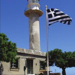
The lighthouse was manufactured in 1864 from the French Company of Lighthouses in Northern part of Crete. The altitude of tower is 9 m and the height of focal plane is 49 m. It is located in the
end of cape Agjos Ioannis and included in the Greek lighthouses network in 1912-13 after the end of Balkan Wars. A historical monument protected by law 3028/02 on "Protection of Antiquities
and Cultural Heritage" and by Law 2039/92 on "Ratification of the Convention for the Protection of the Architectural Heritage of Europe." Thousands of visitors each year visit the region to
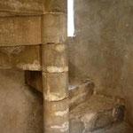
admire this impressive building. The particular aesthetic Lighthouse Aforesmenou facing big problems and static maintenance is now a ruin, in fact in danger of collapsing. The oldest part of
which was a tower that existed here, has disappeared and in recent years lost the metal cover of the lamp. The twisting staircase is open and anyone who wants rises to the top of the lighthouse.
Around the area grows various herbs, shrubs and flowers that are trying to give color and life in the countryside. Efforts are being made to repair the lighthouse but the Greek bureaucracy has
not allowed yet. Recently opened road that leads to the lighthouse for the transportation of materials to repair and enhance.
Lighthouses of Greece: Sideros, Crete Island
Location: Crete Island
Latitude: 35º 18' 57'' N, Longitude: 26º 18' 38'' E
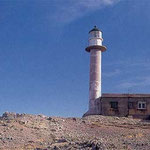
The lighthouse was constructed by the French in 1880 and rebuilded in 1952. The height of tower is 16 m and the focal plane 45 m. The area is also known as Agios Isidorus, "the gift", for a
church established there many years ago after a monk came ashore. He built the little church to give thanks to God, since he had been adrift at sea for many days. Below the cape is a foundation
and parts of columns from a ruined temple to Athena which was destroyed by an ancient tsunami that swept the coast of Crete after an eruption on Santorini Island. Small islands and large rocks
are scattered off Cape Sideros as well as the dangerous Sideros Reef about 548 m east of the cape. Ships make landfall here and round the cape as they steer in and out of the Libyan Sea.
Lighthouses of Greece: Drepano, Crete Island
Location: Crete Island
Latitude: 35º 28' 23'' N, Longitude: 24º 14' 25'' E
The lighthouse was manufactured in 1864 from the French company of lighthouses. The altitude of octagonal stone tower is 7 m and the height of focal plane is 60 m. Near to the lighthouse exists
the little stone house of light-keeper. Located East in the northern side of Crete, near "Souda" bight in the cape "Drepano" 50 m above the surface of sea. It was included in the Greek
lighthouses network after the Balkan Wars 1912-13 but destroyed from the Germans in the 2nd World War and rebuild in 1948. The band is rocky, inaccessible and the most near village, named
"Kokino", is about two-three hours by foot. The coast is very dangerous for each boat that will approach.
Lighthouses of Greece: Gavdos Island, Crete Island
Location: Gavdos Island
Latitude: 34° 50′ 21.19″ N, Longitude: 24° 03′ 31.36″ E
Located about 23 miles south of Sfakia town in Crete, in the dreamy island of Gavdos, the southernmost land of Greece as well as the southernmost border of Europe. Established at 1880, rebuilt at
2003. The original lighthouse stood in the same spot and was a round tower 9 m standing 56 m above the sea and it was visible 25 miles. About 400 people lived on Gavdos at the time the lighthouse
was established. The lighthouse was totally destroyed by fire during World War II. After the war it stood in ruins and skeleton tower light replaced it. Today a 4 meter metal framework tower
provides the beacon flashing once every second from a skeleton light tower on tiny Gavdopoula (means "Little Gavdos") island just offshore of Gavdos Island. Gavdos Lighthouse a replica of the
original light tower stands on the highest point of the northwest part of Gavdos Island. So in light of the historic lighthouse was extinguished. To replace this later constructed another
lighthouse in cape Gavdos SE on Trypiti cape, the southernmost point of Europe. In 1989-1990 built in this part another beacon that works with solar cells. In 2003 a replica of the original
lighthouse was built with European Union funding and opened as a museum about the history of the lighthouse with rooms photos and old equipment. The base of the old lamp was placed in a side near
the lighthouse. Ruins of the 1880 tower lie nearby. Today the lighthouse is one of the attractions of the island with spectacular views!
The replica lighthouse is accessible by a ferry twice a week between Sfakia on Crete and Gavdos Island. The replica lighthouse is open most days, but is closed for a few hours midday. It has a
small population, but is visited by tourist since it is the home of the mythical nymph Calypso of Homer's. The Apostle Paul was here as well on his way to Rome to stand trial. Fifteen centuries
later, the pirate Barbarossa used Gavdos as his hideout. The island has splendid beaches, fragrant herbs, pines and cedars and it is a popular stopover for more than 120 species of migrating
birds.
Lighthouses of Greece: Heraklion, Crete Island
Location: Crete Island
Latitude: 35º 20' 40'' N, Longitude: 25º 8' 12'' E
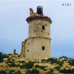
This photo shows how it was before.
This lighthouse was manufactured at 1864 and it's located in the harbor of Heraklion in Crete Island. Today are saved only his certain ruins.
PHOTOS